Exploring the Scottish Borders | Hiking Scotland
If you follow me over on Instagram, you might have noticed that last month all of my photos came from outside Edinburgh. I was visiting my parents (and exploring!) in the Scottish Borders for a few weeks. While staying there, I got to visit a lot of places in the area that I had never been to before, despite having grown up there. My parents moved last year, and we’re a bit more central in the Borders now, which means we’re closer to more places.
There was a lot of walking and hiking, as well as some more relaxed outings. There were varying combinations of family members each time, depending on who was free and keen. I wasn’t blogging at the time, so there isn’t going to be one post for each place. Rather this is my summary of them all for anyone looking for things to do while exploring the Scottish Borders (plus one bonus location in the north of England)!
Eildon Hills
The Borders are full of hills, but there’s a good reason this area is referred to as the Lowlands. You’ll not find the towering, craggy mountains of further north; instead, this is all rolling green hills. The Eildons are not the tallest hills in the area, but they do stick out. Three large mounds rising in the middle of the surrounding flatter valley land. You can’t exactly get lost, as they don’t cover a wide area. You just need to pick a side and start heading uphill. We tackled the north and mid peaks, which are the taller two, and skipped the smaller west hill on our way back down. It’s a pretty steep hike up the first one, but it’s definitely worth it when you get to the top for the views.
The Eildons are the tallest point for miles around, so the Borders just opens up on all sides. Plenty of towns become visible nestled amongst the smaller hills. The Eildons are closest to Melrose, right next to Tweedbank and Galashiels. You can pick out some of the historic sights, such as Melrose Abbey and Abbotsford House, both nearby. It was pretty windy at the top, especially of the mid hill. But we found a sheltered spot to sit and take a break, soaking in the view for a while, before continuing down again. We went up from Rhymer’s Stone, and came down by the reservoir, which also made for a nice walk around to finish up.


Lanton Moor
My parents live near Jedburgh and there’s lots of walking routes nearby, so I didn’t always need to get driven somewhere. Lanton Moor is on the west side of the town, and you can start this walk from the Tourist Information Office in town. It’s basically a walk straight up Tudhope Loaning from there, leading you out of the buildings and up into the fields and farmland. It didn’t take long for us to get high enough up to see the whole town nestled in the valley below us.
We passed by fields of sheep and horses, until we eventually came to the woodland which covers much of the moor. The path here turns on to the Jedburgh Circular Route, a riding route that goes all around the town. It was very peaceful just wandering through the trees. You can also take a detour all the way up to the ruins of Timendean Tower, but we opted not to that day. When you reemerge from the woodlands at the far side, the path will start to lead downhill again until you reach a crossroads. Turning right is the most direct route back to the centre of Jedburgh. Instead, we went straight across to get down to the Jed Water, which we followed towards the town before turning off to go home.


Harestanes & Peniel Heugh
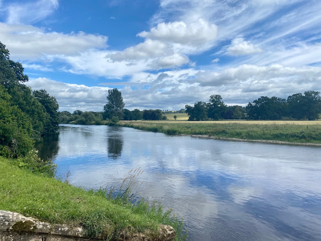
Harestanes is a country park not far from Jedburgh, which is popular for family outings. There are several walking routes, as well as a children’s play park, cafe, and gift shop. I actually ended up here twice during my time in the Borders. Once was with some extended family, starting with a picnic and letting the kids play for a while. Then we embarked on a walk through the woods and back along the Teviot River. It ended up being a bit longer than we had expected, for being the mid-length option. But it was all flat rather than an uphill hike, and it was especially nice alongside the river.
The other time I was here, we ventured up Peniel Heugh, a small hill with the Waterloo Monument on top. It’s not one of the largest hills in the area, but the monument is pretty visible from all around the surrounding area. We can even see it from our house, so it seemed worth checking out. We actually got a little lost, because we started from the Woodside garden centre rather than the visitor centre. This shouldn’t have made a big difference, but Harestanes marks and colour codes its paths and we missed the right signs. We managed to figure out where we were eventually, when we emerged from the woods on to a road below the hill. We only had to make a short reroute to get back on track and make our way to the hilltop, standing beneath the monument and admiring the views.
Most people would go back down through Harestanes, but we actually continued over and down the other side of the hill. This took us to the village of Nisbet, where my aunt lives. She drove us home again, but on another occasion we actually walked from our house to hers along part of St Cuthbert’s Way. This is a long distance walking route, from Melrose to Lindisfarne, which I’ve done a few chunks of now on my many walks.


Dere Street
Speaking of St Cuthbert’s Way, a portion of it overlaps with Dere Street, which is an old Roman road. It goes all the way from the Antonine Wall down to York, including through the Scottish Borders. Part of it can be found to the north and east of Jedburgh, not far away from where my parents live. There’s a couple of options for walking around our area, which usually place you on Dere Street at least some of the time. If you didn’t know you were on it, it would be easy to miss, as it just seems like a narrow, rough trail running through the countryside. Only the fact that it’s almost completely straight would give away that it was a Roman road! It’s a pretty cool thing though, to realise that you’re walking a route they created here almost 2,000 years ago.
Beside the road itself, the routes around the east of Jedburgh take you past lots of arable farmland. There are lots of fields of crops waiting to be harvested at this time of year. It’s a very quiet area too, since there’s no major hill or historic sight that would draw in visitors. I would mostly only encounter other locals, if anyone at all, when walking around here.


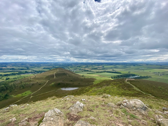
Ruberslaw
You can find the hill of Ruberslaw just outside of Hawick, the largest of the Border towns. It’s also the one we used to live closest too, except we were even further south, right at the end of the Borders. It’s therefore a popular choice for hiking for people from the town. Given that we used to live nearby, and we have an aunt and uncle who farm right beside the hill, it’s a little astounding that none of us had ever hiked it before!
At over 400m, it is one of the larger hills in the area, which made for wide, sweeping views at the top. It’s pretty prominent, but perhaps doesn’t seem so compared to the Eildons, since it has more neighbouring hills. We came up and down it via the same route, from the north west side, where there’s a car park near a camping site. It’s not too steep of a climb really, but compared to my dad and sister, I walk the slowest and seem to be the least fit of us three! As we scaled it, we could see all the way over Hawick to the west. Once we reached the top, we could see over the other side to Abbotrule and Bonchester Bridge.


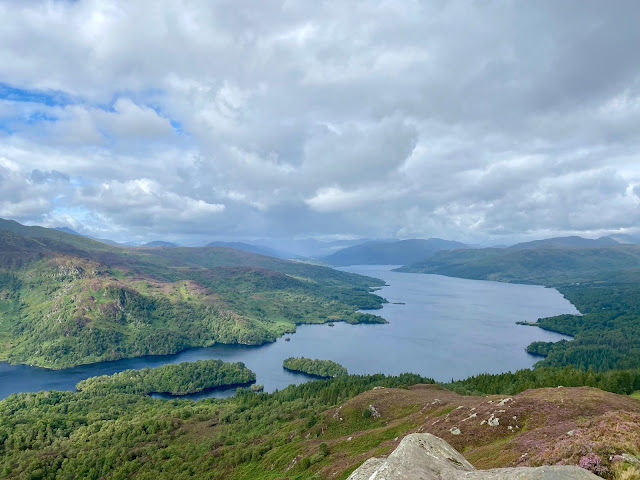
The Three Brethren
This hike gets its name from the three cairns at the top. I haven’t actually been able to find if the hill has another name or not! You can reach them from Selkirk, starting from the Philiphaugh Car Park. They actually sit on the Southern Upland Way, a long distance coast-to-coast route through Southern Scotland. From the car park, we went up through some woodland, and past a reservoir. Then it was straight uphill to where the cairns were visible at the top.
It didn’t take long to get up to the top at all, and it wasn’t that steep either. The views didn’t seem particularly exciting, until we reached the top and turned around. The best of it had been behind us the whole time as we’d ascended! This certainly made for a nice surprise, and we were glad to have a good view as we sat by the cairns, enjoying a break. We would have stayed longer, but there was a cold wind chilling us considerably!
The route down was a circular one, which veered further east to come back own towards Selkirk. The Three Brethren are surrounded by other hills, which all roll into each other. Meaning it wasn’t such a steep descent at all, and we got more views of Selkirk and all the way to the Eildons, on our way down. We missed a turn somewhere and reemerged from the woodland at a farm further along from where we started. Fortunately, it wasn’t too difficult to simply follow the road back along again!


Hirsel Country Park
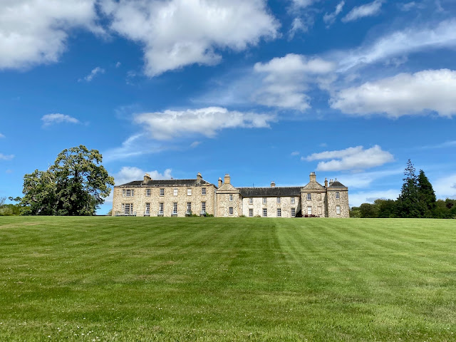
I visited here one day with both my parents and the dog, over near Coldstream. The park area belongs to Hirsel Estate, and there’s a big old manor house in the grounds, which is not open to the public. However, there is a cafe, an arts centre and lots of easy, flat walking routes around the estate. This is an ideal option for anyone with accessibility requirements! The walking routes are all colour coded, and we combined two of them.
We started with the accessible route that follows the paved roads, past the house and some of the other estate buildings. The landscape is mostly flat grassy areas, including a field of Highland cows grazing under the shade of some trees. They were too far away for a decent phone picture though!
We circled around towards the pond, then walked its circumference. This path is rougher and more overgrown, not paved like the roads. It’s actually so hidden in the foliage that you barely see the pond most of the time! There is a small lookout hut halfway around though and lots of ducks to feed on the shore opposite the craft centre. We finished up with a coffee from the cafe and were able to sit outside in the courtyard.

St Abbs
If photos of St Abbs look at all familiar to you, then it could be because this tiny fishing village gained a bit of fame last year, when it used to film the New Asgard scenes for Avengers: Endgame. The signs as you enter town now even read “Twinned with New Asgard”. We purposely visited on a weekday, hoping it would be less busy than at the weekends, but so many people are taking domestic holidays at the moment, especially to rural areas like this, that is was still packed.
We were planning to do a walk around the headland area, and the route is a circular loop from the nature reserve car park. However, it was completely full, as was the harbour car park, so we had to go to the next village down the coast, Coldingham Bay. From here, there’s a coastal path along to St Abbs, which only added twenty minutes or so to our total hike. It also meant we got to walk through the village itself, and got some good views looking over the harbour from the top road.
We finally reached St Abbs Head, and followed the path along the clifftops, heading north towards the lighthouse. The coastal views were beautiful, and we managed to get a clear, sunny day for it. There were plenty of other people around, but it wasn’t overwhelmingly busy. The lighthouse is just a small hub, built into the side of the cliff, without a traditional tower format. Beyond that, we went all the way to Pettico Wick Bay, with its huge, majestic cliffs stretching up the coastline. It was easily the best viewpoint of the route and we could even see the Bass Rock way off in the distance.
To circle back, we cut through the middle of the reserve, alongside Mire Loch. We then retraced our route through St Abbs and back along the coast to the car park. I love being by the coast, so this was definitely one of my favourite days out!


Bonus! – Bamburgh
And speaking of being by the coast, the bonus trip was to Bamburgh, which is across the border in Northumberland (about an hour’s drive from where we live). This wasn’t a hiking trip, but rather a beach outing. Bamburgh is a very scenic choice though, because of the vast castle that stands just above the sand. It had actually reopened to the public the same week we went. We weren’t planning on visiting inside, but it’s still very cool to see it from the outside.
Bamburgh Beach is very long, so even though it was the weekend and pretty busy, we still had plenty of space to ourselves. We took the dog with us, who had never been to a beach before, and walked him all up and down it. He didn’t seem that interested in the sand or sea, just confused as to why every puddle he tried to drink from was salty!
Bamburgh is on the east coast, next to the North Sea, which is as cold as the name suggests. Yet there were still people swimming and surfing – in wetsuits of course! I didn’t do more than get my feet wet in the puddles, as the tide was pretty far out. We sat there for a while, after walking the dog, then headed back up into the village to pick up some sandwiches. We just ate them in the car, as the queues to sit anywhere were huge (thanks to social distancing).


So there we have it, my highlights of exploring the Scottish Borders last month! I definitely did more than I have on a trip home in a long time. Largely because my family and I had the free time to do so, and since we live more centrally now. It’s the longest I’ve been able to spend at home in years without work! And this isn’t even everything! I’ve got a couple more things I hope to go back and do, once more places start to open again soon.


One Comment
Anonymous
Thank you for your beautiful pictures.
From Japan.